 |
Nagaland - The land of festivals
Nagaland, a northeast Indian state, is a beautiful region to visit. One of the smallest states in the country borders many states including Assam in its west, Arunachal Pradesh and part of Assam in its north, Manipur in its south. It also shares international borders with Burma in its east. With a total area of 16,579 sq km, Nagaland provides residence to over 1,980,602 citizens.
Having most of its area mountainous, the state has plains at only those areas which border Assam valley. The highest peak in Nagaland is Mount Saramati with a total height of 3,840 mtrs, forming a natural barrier between Nagaland and Burma by its range. Being an extremely mountainous state, Nagaland’s econmy is largely contributed by agriculture. The state’s main crops are rice, corn, millets, pulses, tobacco, oilseeds, sugarcane, potatoes and fibres, among others. Forestry, cottage industries, insurance, real estate and tourism are other principal contributors to its economy. Other attraction of Nagaland is its metal work done by some certain communities.
Having most of its area mountainous, the state has plains at only those areas which border Assam valley. The highest peak in Nagaland is Mount Saramati with a total height of 3,840 mtrs, forming a natural barrier between Nagaland and Burma by its range. Being an extremely mountainous state, Nagaland’s econmy is largely contributed by agriculture. The state’s main crops are rice, corn, millets, pulses, tobacco, oilseeds, sugarcane, potatoes and fibres, among others. Forestry, cottage industries, insurance, real estate and tourism are other principal contributors to its economy. Other attraction of Nagaland is its metal work done by some certain communities.
How to Reach
- Air: MNagaland has an airport is in Dimapur, 74 kms away from Kohima, the state capital, receiving flights from Guwahati (Assam) and Kolkata (West Bengal) to Dimapur.
- Rail:Its nearest railhead is Dimapur, 74 km from Kohima, linking Dimapur to Guwahati which is connected to the rest of India.
- Road:The road network connects Kohima to Imphal in Manipur (123 km) and Guwahati in Assam (400 km).
Best Time to Visit
- Nagaland faces summers from April to July, with temperature ranging from 16°C to 31°C.
- Monsoon pours the state between June to September, marked by heavy rains.
- Winters stay here between October to April, with temperature ranging from 4°C to 24°C.
From October to May is the best time to visit Nagaland, when rains are far from the state. Between June and September, the state receives extremely heavy rains.
Major Destinations
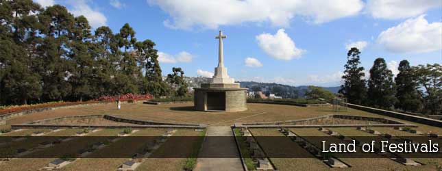
- Kohima : Nagaland’s state capital Kohima, the land of the Angami Naga Tribe, has a ceremonial gateway that displays typical tribal architecture and handicrafts in its house. Kohima is also known for World War II Cemetery, Nagaland State Museum, Japfu Peak, the highest in the state, and Dzukou Valley, 25 km from the town.
- Shangnyu Village : An 8 ft high and 12 ft wide wooden monument stands in this village and is believed that heavenly angels constructed it. The village is ruled by Angh- the hereditary chief; there are other memorial stones in front of the Angh's palace.
- Dimapur: The largest city of Nagaland, Dimapur is famous for the Rangapahar Reserve Forest, the Diezephe Craft Village and mediaeval ruins of Kachari Kingdom.
- Intanki Wildlife Sanctuary: Located at a distance of around 37 km from Dimapur, Intanki Wildlife Sanctuary is well-known forest reserves in Nagaland, housing baboons, elephants, wild buffaloes, barking deer, flying squirrels, tigers, wild dogs, sloth bears and hornbills, etc.
Fairs and Festivals
- Amongmong
- Aoling Monyu
- Chakhesang
- Hornbill Festival (December)
- Horn Bill Festival
- Konyak Festival
- Metemneo
- Nazu Festival
- Nazu Festival
- Phom Monyu
- Sankarni
- Sekrenyi Festival
- Sekrenyi Festival (February)
- Tuluni Festival (July)
- Yemshe Festival
- Moatsu Festival


|